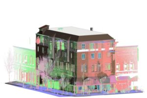

Creating accurate digital representations of physical spaces is a top priority for modern construction and architecture. Professionals need exact measurements to plan renovations, preserve historical sites, or manage complex facilities. This is where point cloud data comes into play. It provides a highly detailed 3D mapping of a physical space using millions of data points collected by laser scanners.
Building Information Modeling (BIM) takes this data a step further. It transforms raw measurements into intelligent 3D models filled with functional data about the building’s components.
Combining these two technologies creates a powerful workflow for the Architecture, Engineering, and Construction (AEC) industry. Converting point clouds into detailed BIM outputs ensures that project planning is grounded in reality, reducing errors and improving overall project outcomes.
The Process of Point Cloud to BIM Conversion
Data Acquisition with 3D Laser Scanning
The journey begins on-site. Technicians use high-definition 3D laser scanners to capture the exact dimensions of a building or site. These scanners bounce lasers off surfaces, recording the distance and angle of each reflection to generate a dense collection of points known as a point cloud.
Data Registration and Cleaning
Once the scans are complete, the data moves to the processing phase. Multiple scans from different angles are stitched together in a process called registration. Technicians then clean the point cloud to remove unwanted noise, such as people walking through the scan or temporary equipment left on the site.
Modeling from Point Cloud Data
The refined point cloud serves as a foundational layer in BIM software like Autodesk Revit. BIM modelers trace over the point cloud, converting billions of raw data points into intelligent architectural, structural, and MEP (mechanical, electrical, plumbing) components.
Benefits of Detailed BIM Output from Point Clouds
Enhanced Accuracy and Precision
Traditional surveying methods leave room for human error. Laser scanning captures site conditions with millimeter-level accuracy. This precision ensures the resulting BIM model represents the exact as-built conditions of the space.
Improved Collaboration and Communication
A detailed 3D model gives all project stakeholders a clear, unified vision. Architects, engineers, and contractors can review the same data, identify potential clashes early, and make informed decisions together.
Cost and Time Savings
Fewer surprises during construction mean fewer costly rework orders. By identifying spatial conflicts in the digital model before breaking ground, teams save significant time and resources.
Facilitating Facility Management
The value of a BIM model extends long after construction ends. Facility managers use these data-rich models to track maintenance schedules, locate hidden MEP systems, and plan future upgrades effectively.
Common Use Cases and Applications
Renovation and Retrofit Projects
Working with existing structures requires a deep understanding of current conditions. Point cloud data provides the exact layout needed to design additions or system upgrades without relying on outdated 2D blueprints.
Historic Preservation
Protecting heritage sites requires extreme care. Laser scanning documents every intricate detail of a historic building without physical contact, providing a digital archive and a reliable base for restoration work.
Infrastructure and Urban Planning
City planners and civil engineers use laser scanning to map out large-scale environments like bridges, roads, and utility networks. This data is critical for safe and efficient urban development.
Quality Control and Verification
During construction, teams can regularly scan the site and compare the new point cloud against the original design model. This verifies that the physical construction aligns perfectly with the intended plans.
Challenges and Solutions in the Conversion Process
Handling Large Datasets
Point cloud files are notoriously massive. Processing them requires powerful computer hardware and specialized software capable of rendering billions of points without crashing.
Ensuring Data Accuracy and Completeness
Scanners require a direct line of sight. Hidden areas or highly reflective surfaces can result in incomplete data. Experienced technicians anticipate these issues and plan their scanning locations carefully to ensure total coverage.
The Need for Specialized Expertise
Translating raw dots into intelligent building elements is a highly technical skill. It demands a deep understanding of both architectural principles and advanced 3D modeling software.
Choosing the Right Service Provider
Key Considerations for Success
Finding a reliable partner for point cloud to bim conversion services is crucial for project success. Look for a provider with a proven track record, up-to-date software capabilities, and a robust portfolio of similar projects. The right team will understand the specific Level of Development (LOD) required for your structural goals.
The Value of Expert Delivery
Working with an established firm like Archdraw Outsourcing ensures you receive highly accurate, detailed BIM outputs. A skilled provider takes the technical burden off your internal team, allowing you to focus on design and project execution.
Building the Future of Construction
Using point cloud data to create precise BIM models is fundamentally changing how the AEC industry operates. It bridges the gap between physical reality and digital planning. By embracing this technology, construction professionals can drastically reduce errors, streamline team communication, and deliver projects more efficiently. As laser scanning hardware and modeling software continue to improve, this conversion process will only become more integral to designing the built environment.