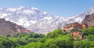

Map of the Atlas Mountains in Africa, you’ll discover one of the continent’s most impressive mountain systems stretching across North Africa. This vast range connects landscapes of rugged peaks, fertile valleys, desert edges, and ancient settlements. Extending from Morocco through Algeria and into Tunisia, the mountain chain has shaped the region’s geography, climate, and culture for thousands of years.
Whether you’re planning a trip, studying African geography, or simply exploring maps, understanding the location and significance of these mountains provides valuable insight into North Africa’s natural beauty and history.
Understanding the Map of the Atlas Mountains in Africa
A map of the atlas mountains in africa typically highlights a mountain system spanning approximately 2,500 kilometers (1,550 miles). The range begins near Morocco’s Atlantic coast, crosses northern Algeria, and reaches northeastern Tunisia before gradually fading into lower hills.
These mountains create a natural barrier between the Mediterranean coastline and the vast Sahara Desert. Because of this position, they influence rainfall, temperatures, and ecosystems across much of North Africa.
On most physical maps, the mountains appear as a long arc running southwest to northeast. Elevation colors often show dark brown or reddish shades to represent the higher peaks.
Morocco: Where the Highest Peaks Rise
Morocco contains the most famous and dramatic sections of the range. The country’s mountain landscapes attract hikers, photographers, and adventure travelers from around the world.
Several important subranges can be identified on regional maps:
- High Atlas
- Middle Atlas
- Anti-Atlas
The High Atlas contains the tallest mountain in North Africa, Jebel Toubkal, which rises to 4,167 meters (13,671 feet). Snow regularly covers its summit during winter, creating a striking contrast with nearby desert landscapes.
Many popular tourist destinations such as Marrakesh serve as gateways to mountain villages and hiking routes.
Algeria: The Longest Mountain Section
Moving eastward, the map of the atlas mountains in africa shows that Algeria contains the longest continuous portion of the mountain system.
Two major divisions dominate this region:
- Tell Atlas near the Mediterranean coast
- Saharan Atlas farther south
The Tell Atlas receives more rainfall and supports forests, agriculture, and numerous cities. Meanwhile, the Saharan Atlas forms a transition between greener northern regions and the dry Sahara.
These mountain belts create diverse environments ranging from cedar forests to rocky plateaus.
Tunisia: The Eastern End of the Range
The mountains gradually decrease in height as they enter Tunisia. Although smaller than those in Morocco, they remain important geographical features.
The Tunisian section includes scenic hills, forests, and protected natural areas that support local wildlife. These elevations also influence regional agriculture by capturing rainfall that would otherwise bypass the area.
Travelers exploring Tunisia often encounter mountain landscapes alongside Roman ruins, traditional villages, and olive groves.
Major Mountain Ranges Visible on Maps
A detailed map of the atlas mountains in africa often separates the system into several recognizable ranges.
High Atlas
Home to North Africa’s tallest peaks and dramatic valleys, this region is popular for trekking and mountain climbing.
Middle Atlas
Known for cedar forests, freshwater lakes, and diverse wildlife, the Middle Atlas offers cooler temperatures throughout much of the year.
Anti-Atlas
Located farther south, this older mountain chain features unique rock formations, arid scenery, and ancient geological structures.
Tell Atlas
Running close to the Mediterranean coast, the Tell Atlas supports fertile farmland and many major population centers.
Saharan Atlas
This southern section forms an important transition between mountain landscapes and the Sahara Desert.
Why These Mountains Matter
Looking beyond geography, the mountains have influenced civilizations for thousands of years.
Communities settled in fertile valleys where rivers supplied water for farming. Trade routes crossed mountain passes connecting Mediterranean ports with interior regions. Today, many traditional Berber villages continue to preserve customs that date back centuries.
The mountains also act as natural climate regulators by capturing moisture from Atlantic and Mediterranean weather systems.
Without them, much of North Africa would be significantly drier.
Climate Across the Mountain Chain
The climate changes considerably depending on elevation and location.
Higher elevations experience:
- Cold winters
- Seasonal snowfall
- Mild summers
- Greater rainfall
Lower slopes generally have:
- Warm Mediterranean conditions
- Productive farmland
- Forests
- Vineyards and orchards
Southern slopes gradually become much drier as they approach the Sahara Desert.
This dramatic transition is clearly visible on many physical and climate maps.
Wildlife and Natural Diversity
A map of the atlas mountains also helps identify important ecological zones.
The mountains support remarkable biodiversity, including:
- Barbary macaques
- Golden eagles
- Barbary sheep
- Foxes
- Wild boars
- Numerous migratory birds
Plant life varies from cedar forests and oak woodlands to alpine meadows and desert shrubs.
Many national parks protect these habitats, ensuring the survival of rare species found nowhere else.
Rivers Originating in the Mountains
Many of North Africa’s important rivers begin in these highlands.
Snowmelt and seasonal rainfall provide water that supports:
- Agriculture
- Drinking water
- Hydroelectric projects
- Wetlands
- Irrigation systems
Without these mountain watersheds, farming across large areas of Morocco, Algeria, and Tunisia would be much more difficult.
Reading a Physical Map
When studying a atlas mountains in africa, several features become immediately noticeable.
Look for:
Brown elevation shading indicating mountain heights
Green valleys showing fertile agricultural areas
Blue rivers flowing north toward the Mediterranean or west toward the Atlantic
Desert colors expanding southward into the Sahara
National borders crossing the mountain chain
Modern digital maps also display hiking routes, national parks, villages, and scenic viewpoints.
Popular Destinations Along the Mountains
Travelers frequently visit destinations located throughout the mountain regions.
Popular locations include:
- Marrakesh
- Imlil
- Ouarzazate
- Tizi n’Tichka Pass
- Kabylie region in Algeria
- Kroumirie Mountains in Tunisia
These areas offer opportunities for hiking, cultural experiences, photography, and outdoor adventure.
Geological Formation
The mountains formed through millions of years of tectonic activity as the African and Eurasian plates interacted.
This geological history produced:
- Folded mountain ridges
- Deep valleys
- Limestone cliffs
- Volcanic remnants
- Rich mineral deposits
Scientists continue studying these formations to better understand Earth’s geological evolution.
Conclusion
A map of the atlas mountains in africa reveals far more than a mountain chain stretching across Morocco, Algeria, and Tunisia. It illustrates a region that has shaped climates, cultures, ecosystems, and civilizations for thousands of years. From the snow-capped High Atlas peaks to the forested hills of Tunisia, the landscape showcases incredible diversity within North Africa.
Whether viewed on a printed atlas or an interactive digital map, these mountains remain one of Africa’s defining geographical features. Understanding their location and significance helps travelers, students, and geography enthusiasts appreciate how this remarkable range connects the Mediterranean world with the edge of the Sahara while preserving a rich natural and cultural heritage.